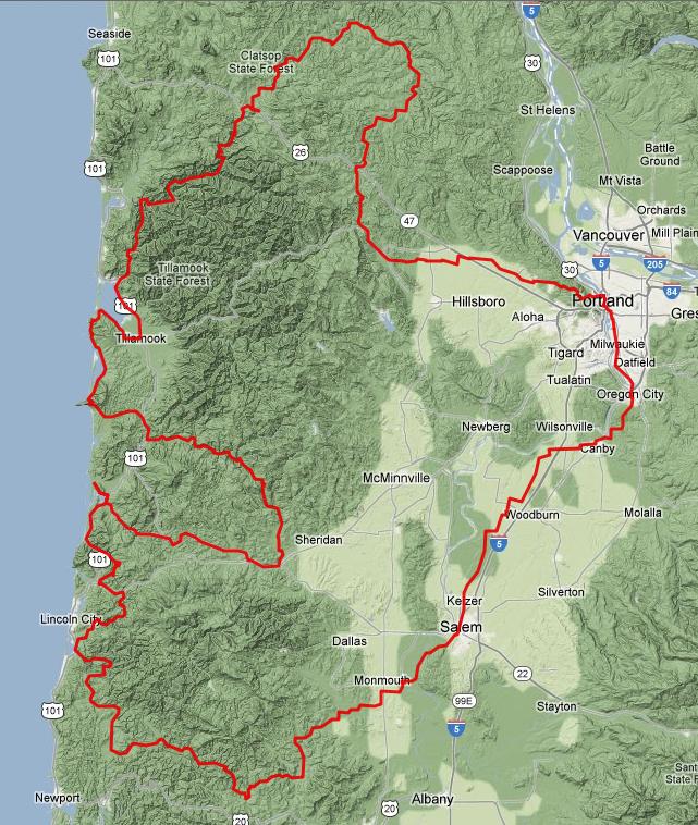
Beautiful, isn't it?
This is my twelfth registered permanent, a multiday whopper designed to take advantage of two things: first, a RUSA rule which relaxes the time limit for rides >700K; and second, my grandmother's big lovely house in Oceanside that would serve perfectly as a mid-ride overnight rest stop.
Thus, time to introduce: GRAWP.
- Distance: 712K
- Elevation: 25,832 feet according to RideWithGPS
- Route
- Cue sheet
- Registration
It's enormous and awesome -- the name selection was pretty easy.
This is the end product of basically throwing a bunch of my favorite roads onto a map and finding a way to get them to stick together.
The initial southwest-bound crawl out of Portland is pretty straightforward -- taking well-traveled roads through Oregon City and Canby, then joining up with the official Willamette Valley scenic bike route and crossing over the Independence Bridge.
I aped the Independence-Kings Valley connection from Joshua's 600, then used the gravel Hoskins Rd to get over to Logsden which I last traveled on 2011's coast 600K. The seventy or so following miles are almost the same as what was used for Susan's ride, just reversed and extended out to Bear Creek Rd rather than a longish stretch of Hwy 101 towards Pacific City.
In Pacific City, you make a U-turn to go back and take Little Nestucca River Rd and Hebo Rd up to Willamina (this stretch lifted from the Three Capes 300K). Whereas that ride ducks back towards Forest Grove, mine sends you straight north out of Willamina for the toughest climb of the ride, towards Bible Creek Rd and a connection with Nestucca River Rd.
Going north over Cape Lookout is only about a 600-foot climb, nothing too outrageous, but watch for poorly maintained pavement. After passing through Netarts and Oceanside, my same comment applies for Cape Meares.
Stock up on food at the 24-hour (edit: closes at 1am) Tillamook Safeway, since you'll have a rather remote stretch on Miami-Foley Rd then the newly reopened Foss Rd (now with intact bridge!). Foss is about eighteen miles of rough gravel -- just what everyone wants to see at mile 320!
There's a restaurant and market on the short stretch of Highway 26 you need to use to connect to Hwy 103, which will likely be much-needed after the gravel stretch. Or, you can make that stop a relatively quick one and instead get a longer sit-down meal at the always-popular Birkenfeld store, about twenty miles later.
Unfortunately, the route just wasn't quite long enough if I used the Banks-Vernonia Trail, so instead you take a longer way back via Timber Rd. The final stretch is straightforward and well-used -- Clapshaw Hill, West Union, Laidlaw, Thompson, and Cornell.
Then, voilà, 712K done!
David and I will be riding this starting 5pm on Friday (yes, that's October 20). Overnight lows in the 40s, 30% chance of rain in most places along the route. Should be... interesting, if nothing else.
