Showing posts with label gravel. Show all posts

Sunday, March 29, 2015

Permanent #2678 -- George Weasley Populaire


This is a fun one! Well, Fun for me, at least. YMMV.

Like #2600, this is a trip to Ellensburg and back. Unlike that route, though, this one takes a much more interesting way to head north.

You go the same way through Selah, but head northeast onto Wenas Road instead of going along the Yakima River's canyon. This climbs gradually for about eighteen miles, with consistently nice views of desert ridges and one lake that will seem rather inviting on a hot summer day.

At mile 26, there's an info control to make sure you're actually doing this silly ride, then the magic happens: the pavement ends, gravel begins, and the road starts going way the hell upwards.

Or, specifically: it goes up about 900 feet in 3.7 miles. Hardly the highest amount in the world; it's a little tougher in sheer elevation than Cornell Rd in NW Portland from 25th to Skyline. A lot tougher in practice, though, since it's mostly exposed desert roads covered in dirt and loose gravel.

With that said, as the photo indicates, I was able to pass through without too much trouble on 23mm tires back in the early fall. After you summit at about 3100ft, there's a little bit of gravel descending that's mostly straight-ish and not too hairy; then, thankfully, the rest of the downhill back into Ellensburg is on pavement.

Get some fast food (I recommend the cheapo chicken sandwiches at Carl's Jr), then it's back to Yakima via WA-821. It's flat-ish compared to what you did earlier in the day, all on good pavement, and will offer a little cool air coming off the Yakima River in even the hottest weather.

There are two long stretches between services on this ride, so be careful and pack plenty of water especially in summer: from mile ~20 (a RV park with small market) to Ellensburg at mile 45, then from there to Selah at mile ~75.

Tuesday, March 19, 2013

Permanent #1894 -- Irma Pince


Surprisingly, my 19th registered RUSA permanent is my first which comes close to be a "true" 200K that both starts and ends in Portland.

Also surprisingly, none of the previous eighteen routes took advantage of perhaps my single-favorite stretch of road in the greater Portland area -- Pumpkin Ridge to Smoke Ranch, as seen here from a ride report a while ago.

As you can see, the best parts of the ride are unpaved; on this route, about 20 total miles on either gravel or dirt. You can certainly navigate everything on a road bike with narrow tires, but you'll have a better time with some wider rubber between your legs.

It's also a damn hilly route, with a handful of climbs competing for the title of "best part of the ride". Going up a furlong (which I learned was an eighth-mile at bar trivia yesterday) of loose gravel at 12% on Pumpkin Ridge might be a good pick, or there's a similar stretch on the paved Mountain View Road which is particularly painful since it comes just two miles after a quick control stop in Scappoose.

After Canaan Rd spits you out on Highway 30 at the Deer Island mini-market, your last 45 miles of the day will all be dead-flat. A loop around the east backside of Scappoose gives you some lovely quiet miles instead of the usual bustle of 30 (and is needed to put the route over 200K), but then it's back on the highway and returning to SE Portland.

Monday, March 18, 2013

Permanent #1707 -- Gellert Grindenwald

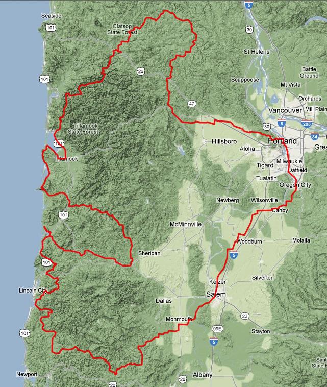
If a bird flew due west from Sellwood, it'd hit Netarts in right around sixty miles. Taking Highway 6 along the Wilson River makes it about eighty. Going the super-long caret-shaped (i.e, the symbol above the "6" on your keyboard) for this scenic route makes it just under a hundred and forty.

To get towards Birkenfeld, you have two options, and I chose to use Highway 30 and Scappoose-Vernonia Road rather than misc roads through the west hills and North Plains. This way is a good bit shorter, slightly flatter, and offers you a chance to ride on the Crown-Zellerbach dirt road which parallels the S-V. The high point there is around 1300 feet, so check snow levels and road conditions if you want to ride in wintertime.

After a well-traveled stretch of 47 & 202, Birkenfeld falls almost exactly at the 100km point. The little general store there recently stopped selling liquor, so you can't grab a mid-ride pull of Bulleit, but they make great hot sandwiches and have the usual market fare (chips, soda, candy).

A bit later, you get to ride the entire 9-mile duration of Highway 103, and there's another market available once you come out on 26. You do spend about three downhill miles on the rather busy and narrow-shouldered 26, but it's certainly survivable.

From there, it's maybe five miles from 26 to Henry Rierson (at mile 97), and then the gravel fun begins. The conclusion is obviously the same as #1706 -- Foss to Miami-Foley to 101 to Tillamook to Netarts. Fun stuff!

Sunday, March 3, 2013

Permanent #1875 -- The Bloody Baron

#1875 -- The Bloody Baron
This one is, at least in parts, positively Rapha-esque. After a straightforward route from SE Portland to Camas, you head north and, though you'll never really be more than 20 miles from the suburbs, you'll feel like you're in the middle of nowhere.

You use L-1000 and Dole Valley Rd to carve a winding path up towards Amboy, in the foothills of Larch Mountain (no, not THAT Larch Mountain, nor the other Larch which you see signs for off OR-6). This route tops out at just under 2,000 feet of elevation, and my favorite, though usually inaccurate, route mapping site guesses there's over 6,000 feet of climbing in the middle fifty miles of this route.

There really isn't much civilization between Camas and Yacolt (the small town just south of the turnaround in Amboy), and with some rather rough gravel roads you should plan accordingly with clothing, food, and tools. I think the only quasi-commercial building you'll pass over a 20-ish mile stretch is a jail, and that's not exactly where you want to pull up to beg to use their phone if you have a mechanical failure.

There's about 15 miles of gravel in each direction -- heading north, they're mostly (but not entirely) downhill (with some rather steep grades in spots); on the return trip, you get, well, the opposite. Different riders will find one or the other to be preferable. I'd recommend riding it with at least 30mm tires, and will be using 40+mm myself, though if you're comfortable and familiar with gravel on a road bike it's doable on anything.

So -- if you've grown tired of Dixie Mountain and Otto Miller, head up over the I-205 bridge and check this one out.

Tuesday, November 6, 2012

Permanent #1706 -- Ludo Bagman

After our success -- in some sick sense of the word -- on the 712K two weeks ago, I was resolved to use Foss Road a hell of a lot more, and that led to two new permanent submissions. First, a simple out-and-back ride from Netarts; second, a Portland-to-Netarts commute that goes through Birkenfeld and is my third such one-way perm between those two points, along with a Nestucca River trip and the most direct Highway 6 route.
Foss... it'll definitely keep you on your toes.


On the 700K, we hit this right at sunrise, at mile ~330 on two hours of sleep, and it was like manna from heaven. No drifting off to sleep when you're darting (and, once or twice bunnyhopping) basketball-sized potholes and chunks of dying pavement. Lots of darting up and down 30 or 50 or 100 feet at a time, one nigh unrideable wall that seemed like a 20% grade, then a more mellow stretch to get to Henry Rierson campground, which'll be the turnaround for this 157K.


The campsite has drinkable water and some pit toilets, though I can't 100% guarantee that either will be in service year-round. There's another campground much earlier on Foss -- mile 34 on my cue sheet -- which claims to have drinking water, but I've been burnt before by relying on never-updated county and state park websites, so... I'll assume it's not there 'til I can roll by and inspect in-person.

To get to the awesometastic gravel stretch, it's a really simple route -- Netarts into Tillamook, north on 101, then inland for Miami-Foley Road. Pavement ends right after the recently reopened bridge over the Nehalem River (though the washed-away railroad in the same spot has not been repaired), seven miles after you turn off Miami-Foley.

Bring plenty of snacks and water, some wide-ish tires (David rode this on Nomad 28s and was quite happy), and you'll love it.

Monday, October 15, 2012

Permanent #1691 -- Grawp


Beautiful, isn't it?

This is my twelfth registered permanent, a multiday whopper designed to take advantage of two things: first, a RUSA rule which relaxes the time limit for rides >700K; and second, my grandmother's big lovely house in Oceanside that would serve perfectly as a mid-ride overnight rest stop.

Thus, time to introduce: GRAWP.
It's enormous and awesome -- the name selection was pretty easy.

This is the end product of basically throwing a bunch of my favorite roads onto a map and finding a way to get them to stick together.

The initial southwest-bound crawl out of Portland is pretty straightforward -- taking well-traveled roads through Oregon City and Canby, then joining up with the official Willamette Valley scenic bike route and crossing over the Independence Bridge.

I aped the Independence-Kings Valley connection from Joshua's 600, then used the gravel Hoskins Rd to get over to Logsden which I last traveled on 2011's coast 600K. The seventy or so following miles are almost the same as what was used for Susan's ride, just reversed and extended out to Bear Creek Rd rather than a longish stretch of Hwy 101 towards Pacific City.

In Pacific City, you make a U-turn to go back and take Little Nestucca River Rd and Hebo Rd up to Willamina (this stretch lifted from the Three Capes 300K). Whereas that ride ducks back towards Forest Grove, mine sends you straight north out of Willamina for the toughest climb of the ride, towards Bible Creek Rd and a connection with Nestucca River Rd.

Going north over Cape Lookout is only about a 600-foot climb, nothing too outrageous, but watch for poorly maintained pavement. After passing through Netarts and Oceanside, my same comment applies for Cape Meares.

Stock up on food at the 24-hour (edit: closes at 1am) Tillamook Safeway, since you'll have a rather remote stretch on Miami-Foley Rd then the newly reopened Foss Rd (now with intact bridge!). Foss is about eighteen miles of rough gravel -- just what everyone wants to see at mile 320!

There's a restaurant and market on the short stretch of Highway 26 you need to use to connect to Hwy 103, which will likely be much-needed after the gravel stretch. Or, you can make that stop a relatively quick one and instead get a longer sit-down meal at the always-popular Birkenfeld store, about twenty miles later.

Unfortunately, the route just wasn't quite long enough if I used the Banks-Vernonia Trail, so instead you take a longer way back via Timber Rd. The final stretch is straightforward and well-used -- Clapshaw Hill, West Union, Laidlaw, Thompson, and Cornell.

Then, voilĂ , 712K done!

David and I will be riding this starting 5pm on Friday (yes, that's October 20). Overnight lows in the 40s, 30% chance of rain in most places along the route. Should be... interesting, if nothing else.

Monday, August 27, 2012

Permanent #1649 -- Horace Slughorn


I had a nice present waiting in my inbox after this weekend's 600K (report forthcoming) -- two new permanent approvals.

It's a shame that I'm in no shape to ride more than a few miles today, though, because this one in particular looks like an awesome one -- lots of dirt and gravel and climbs and descents and the other good things that make for great bike rides.

This covers the entire length of both Leif Erickson trail and Saltzman Road as they cut through Forest Park. Each stretch is very frequently used by roadies and is certainly "doable" on 23mm tires, but would probably be more enjoyable with extra cushioning. Bring a decent set of brakes, too -- particularly for the easternmost segment of Saltzman after it crosses Leif.

The rest of the route (which, as a first for me, comes in at a neat and perfectly even 100km) sends you on a few of the somewhat "hidden", lesser-used roads of deep northwest: Old Germantown, Kaiser, Moreland, and Pederson.

One downside of this rather circuitous route is that it needs seven info control stops, but there's certainly enough climbing so you won't mind being forced to briefly stop in a few spots. If you need to pick up food or water, the best bet is probably the store at the intersection of Skyline and Cornelius Pass, which you'll pass at mile 24 & 43. They even have a water spigot in front of their building which is open to cyclists, but be sure to make an actual snack purchase every now and then to show a little appreciation.